This post is part of Kalahari Series II – 2011. The previous post in the series is Take your camera to the bathroom (and other Kalahari safari tips). Also see Kalahari Series I – 2009.

Map: Southern Cape to Upington (Source: Google Maps) – Click on map to enlarge
Every Kalahari trip starts with a long drive north from the Southern Cape, via Upington, to Twee Rivieren at the gates of the Kgalagadi Transfrontier Park. The first day’s tiring drive through the Little and then Great Karoo to Upington, is shown on the map on the left from A to B. It’s a distance of approximately 860 kilometres, and takes around 10 hours to drive. We took the route passing through Oudtshoorn, Beaufort West, Three Sisters, Victoria West, and Britstown. This is not the shortest route, but it is the easiest route to travel because all the roads are tarred and in good repair – except for the current detour between George and Oudtshoorn due to rain induced road damage.
I am going to tell the story of this trip mainly in photographs – some of which were taken at high-speed and through the windscreen! There were so many photo opportunities along the road, but in order to get to Upington by early evening, we had to drive continuously and stop as little as possible. So I have not got a lot of photographs of the towns along the way.
It was a cold, rainy winter’s day when we left home.

Ready to begin the adventure – Standing at our front door facing the street and the two bare trees in our front yard. ©LB/notesfromafrica.wordpress.com
Crossing over the Outeniqua mountains (a coastal range) we found fairly cloudless skies – and plenty of sunshine. The Little Karoo lies between the coastal mountains and the inland mountain ranges.

This is a map showing the location of the two Karoo ecoregions of southern Africa, as delineated by the World Wide Fund for Nature. The yellow line encloses the two ecoregions. The green line separates the Succulent Karoo, on the west, from the Nama Karoo, on the east. National boundaries are shown in black. (Map Source: Pfly via Wikimedia Commons) Click on map to enlarge
From Wikipedia:
As the name implies, the Little Karoo is the smaller (and more southerly) of the two Karoo sub-regions. Locally it is usually called the Klein Karoo, which is Afrikaans for Little Karoo. Geographically it is a fertile valley (bounded on the north by the Swartberg, and on the south by the Langeberg and Outeniqua mountains). Although the boundaries of the region are not strictly defined, most people consider the western limit of the Little Karoo to be in the region of Barrydale and the eastern extremity around Uniondale.
The main town of the region is Oudtshoorn. Other towns/settlements in the region include Ladismith, Calitzdorp, De Rust,and well-known mission stations such as Zoar, Amalienstein, Barrydale and Dysselsdorp.
This area was first explored by European settlers in the late 17th century, who encountered only Khoisan people living in this rather dry area. Modern farming methods have brought productivity and wealth to this district . . . Read more . . .

A farm in the Little Karoo between George and Oudtshoorn. Love the red rocky ridge at the back. ©LB/notesfromafrica.wordpress.com

A light dusting of snow on the Swartberg Mountains behind Oudtshoorn. ©LB/notesfromafrica.wordpress.com
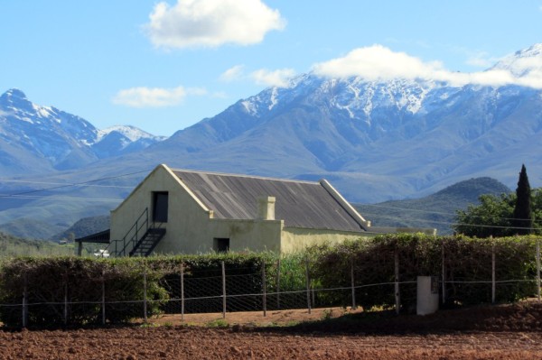
A farm with the snowy Swartberg Mountains behind. ©LB/notesfromafrica.wordpress.com
Driving through Meiringspoort (a passage, carved by a river, through the Swartberg mountains), one leaves behind the Little Karoo and enters the Great Karoo.
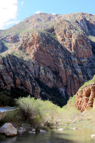
Driving through Meiringspoort. ©LB/notesfromafrica.wordpress.com
You may recognize the rock formations from a previous post (Swartberg Pass: A drive to Hell and back). This gap is in the same mountain range.
Then we were in the Great Karoo. Which is an extremely flat and arid area known for its long, straight roads. The vegetation tends to be low scrub and grasses, with very few trees (which only grow where there is water available).
From Wikipedia:
The Great Karoo has an area of more than 400,000 square kilometers. From a geological point of view it has been a vast inland basin for most of the past 250 million years. At one stage the area was glaciated and the evidence for this is found in the widely-distributed Dwyka tillite. Later, at various times, there were great inland deltas, seas, lakes or swamps. Enormous deposits of coal formed and these are one of the pillars of the economy of South Africa today. Volcanic activity took place on a titanic scale. Despite this baptism of fire, ancient reptiles and amphibians prospered in the wet forests and their remains have made the Karoo famous amongst palaeontologists.
Western people first settled in the Cape in 1652 but made almost no inroads into the Karoo prior to about 1800. Before that time, large herds of antelope, zebra and other large game roamed the grassy flats of the region. The Khoi and Bushmen, last of the southern African Stone Age peoples, wandered far and wide. There were no Europeans and no Africans of Bantu extraction . . .
. . . Currently sheep farming is still the economic backbone of the Karoo, with other forms of agriculture established in areas where irrigation is possible. Lately game farms and tourism have also started to make an economic impact . . . Read more . . .

Nearing Beaufort West. Even the Karoo mountains near Beaufort West had a little snow on them. ©LB/notesfromafrica.wordpress.com
Beaufort West (the largest town of the Great Karoo) has some beautiful buildings, and because it’s a bigger town, we slowed down enough to take some photographs.
Driving down the main road of Beaufort West. ©WMB/notesfromafrica.wordpress.com
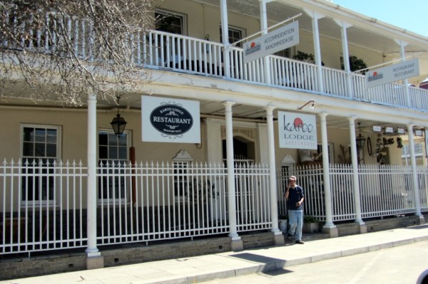
Along the main road in Beaufort West. ©LB/notesfromafrica.wordpress.com
To the north of Beaufort West . . .

Typical scenery in the Great Karoo. ©LB/notesfromafrica.wordpress.com

©LB/notesfromafrica.wordpress.com
©LB/notesfromafrica.wordpress.com
A pit-stop at the Three Sisters Shell Ultra City. All that is here is a re-fuelling station and fast-food restaurant. We got here just after 13:00 (1 p.m.) and the sun was hot and the glare intense.

At the Shell Ultra City near Three Sisters. People like planting cacti and Kokerbome (Aloe dichotoma) together! ©LB/notesfromafrica.wordpress.com
For more information on the Kokerboom read this Wikipedia article, and take a look at this post – Quiver Tree Forest near Nieuwoudtville.
Nearby are the Three Sisters koppies from which the re-fuelling station gets its name. For children in South Africa this is an absolute milestone. It’s on the main route from Johannesburg to Cape Town, and breaks the monotony of driving through the Karoo. A place to get out, get some refreshments and get rid of all that energy that has been building up in the car.

The landmark Three Sisters koppies. ©WMB/notesfromafrica.wordpress.com
A lot of people do not like the Karoo, but I think there’s a lot of beauty in it if you look carefully. Like the Kalahari, it is a very unique landscape. In the intense heat the sky is often pale and the colours of the landscape get washed out. Then you’ll come across a very bold feature like the one below.

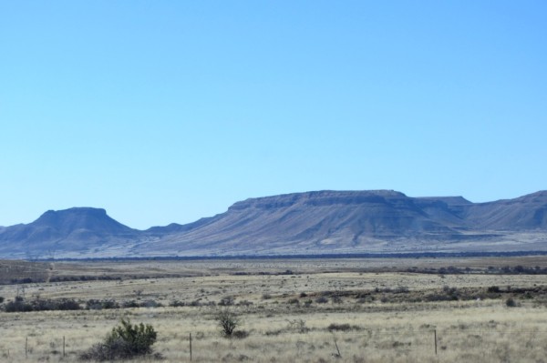
North of Three Sisters some interesting hills with piles of black rock (maybe Dolerite?). ©LB/notesfromafrica.wordpress.com

Close-up of pile of black rocks. ©LB/notesfromafrica.wordpress.com
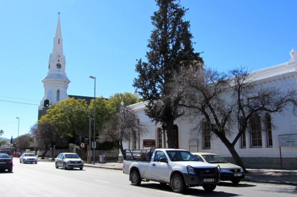
Although we did not take many photographs of the towns, this church in the little Karoo town of Britstown really stood out.

The church in Britstown. The sky was very blue behind the white church. ©LB/notesfromafrica.wordpress.com
After Britstown one starts to turn north-east towards Upington. This is one of the most difficult bits because the roads are very straight and endless, with long distances between towns. Mostly one doesn’t even drive through the towns, but just passes by them from a distance.
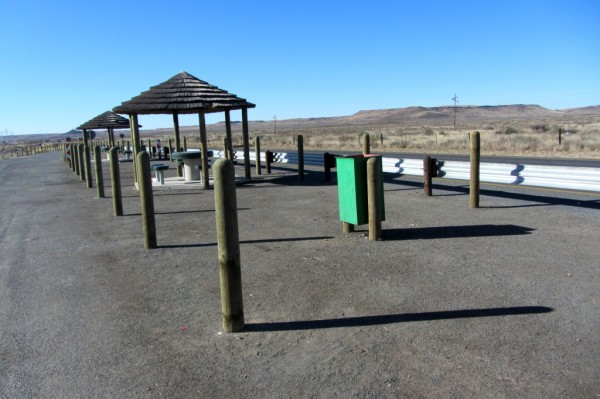
A picnic spot North-east of Britstown. With no trees able to grow well in this environment, artificial shade had to be created. ©LB/notesfromafrica.wordpress.com

Another very straight road in the Northern Cape. ©LB/notesfromafrica.wordpress.com
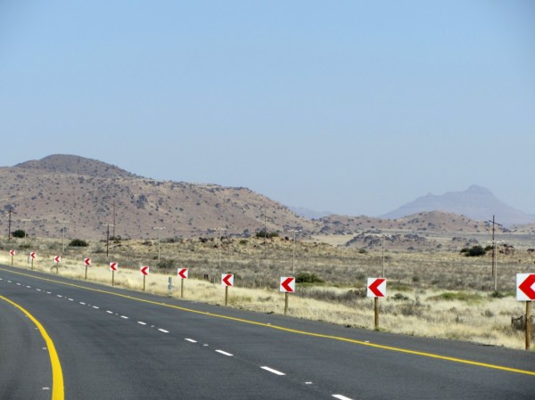
And sometimes to keep you awake, a very sharp bend! ©LB/notesfromafrica.wordpress.com

You know you’re getting close to Upington and the Kalahari when you start seeing these sociable weaver nests. ©LB/notesfromafrica.wordpress.com
If you want to know more about the Sociable Weaver bird, read this post from the Kalahari Series I – Kalahari: Little Birds.

A small settlement near Upington. ©LB/notesfromafrica.wordpress.com
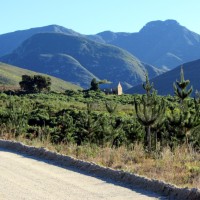
Close to Upington, the scenery changes with hills and more savanna-type vegetation.
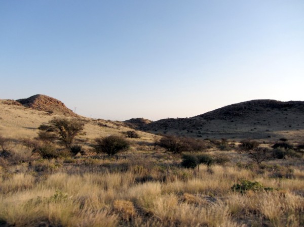
Hilly countryside near Upington. ©LB/notesfromafrica.wordpress.com
By now it was late afternoon/early evening and it became difficult to take photographs.
The next installment of The Long Road North will be following shortly . . .
The Kalahari 2011 Series:
- An oasis in the desert
- Take your camera to the bathroom (and other Kalahari safari tips)
- The long road North – Southern Cape to Upington (this post)
- The Long Road North – Upington
- Showing your kid where its food comes from
- Fierce Creatures
- Gemsbok Graphics
- The Long Road North – Upington to Twee Rivieren and beyond
- Campfire story: The Last Outpost
- Slip-Slap-Slop-Slide and other Bush Beauty Tips
- Nossob
- Hey Mom . . . wait for me!
- A tough customer
- Frenzy at the “water hole” – includes the movie
- The Camp Cat


Thanks for all the pictures. I feel like I was on the trip with you.
Glad that you enjoyed the post! I was hoping to convey a sense of moving through one area to another through the photos.
Love it, love it, love it!
I am so enjoying going on your Road Trip with you, Lisa. You’ve struck the perfect combination of photographs and factual explanations – learning a lot here!
I’d always wondered about the Three Sisters – I actually thought they were a constellation in the sky, not a geographical place in the Karoo. How intriguing…
Thank you, Reggie! A lot of what I learnt about putting together a blog post is from reading YOUR blog!
If you didn’t know about the Three Sisters you obviously didn’t spend your childhood, going on trans-Karoo holidays! 😉
Actually, I took the bus (usually the Intercape Mainliner) from Cape Town to Windhoek and Swakopmund at least once, sometimes twice, a year for many years when I was a kid. So I know the N7 north *very* well.
Last year, when I joined a group of people from the Defence Reserves going up for Artillery Open Day in Potchefstroom, was the first time I had been that far ‘northeast’ from Cape Town. On the way back, we visited Kimberley and the famous Big Hole, which was amazing.
Other than that, I haven’t been outside the boundaries of the Western Cape – well, I’ve been to Port Elizabeth in the Eastern Cape once. Hrmpf. It’s quite ridiculous. *Tourists from overseas* have seen more areas of *my* country than I have!
So I’ve decided: I’ve definitely got a Great South African Road Trip in my future! 😉
Were you born in Namibia or South Africa? Don’t they say, “join the army and travel the world”?! Oh no wait, that’s the navy! The army though will obviously get you as far as Potchefstroom! 😉 I love that you’re getting drawn into their activities through your blog.
If you are a “genuine” South African then I think it is terrible you haven’t been able to travel more throughout South Africa. 😉 My parents firstly moved us around a lot, but we also took a month long holiday every year and mostly travelled somewhere we hadn’t been before – in South Africa and Namibia. I am only appreciating now as an adult what a privilege that was.
I was born in Namibia, but I moved to SA when I started going to school. I regard myself as ‘at home’ in both countries, though I have hardly done any travelling… SO FAR! 😉
“Join the Navy and see the World – Join the Army and see Potch”!!! You are hysterical, Lisa! Giggling…..
You were indeed very fortunate to see so much of our two countries – this is such a beautiful part of the world, and I want to see ALL of it before I die – and before the environment has changed beyond recovery.
The pile of rocks have such a smooth and shiny surface. Is there obsidian in Africa?
I’m not sure if we do have obsidian in Africa. Wikipedia doesn’t list it as a place it occurs. Also I think these are proper rocks as opposed to the volcanic glass-type rock of obsidian. I have asked Lu (from The Unwitting Traveller) – who is a geologist – if she knows what they are.
Fascinating, Lisa. The mountains are stunning–truly stunning. And the sociable weaver nest is fun to look at. I have never seen a nest that looks like that. Great post, my friend!
Kathy
Thanks Kathy! There is going to be a special post about the weaver birds.
I looks so interesting. I love the Karoo!
Glad you liked the post! 🙂
I love traveling vicariously with you on this trip. I’m seeing things I’ve never seen before. Those weaver nests?!?
The Three Sisters Koppies look very similar to the hills in the Painted Desert in Arizona.
How long did the drive take you?
I’m going to have a special post about the Sociable Weavers soon. I’ve heard comparisons made between the Karoo and the Painted Desert before.
It took us about 9 and a half hours this time, with only two very short breaks. We had a late start in the morning and couldn’t afford to waste time.
That is a looong drive! Not sure I would’ve stayed awake to capture the route as well as you did. 🙂
I don’t usually fall asleep in the car, so needed something to pass the time! 🙂
“Hilly countryside . .. ” is a framer. Nice shot!
Thank you! That was one of the “high-speed” shots, so I’m amazed at how well it came out.
There are some seriously straight roads in the Northern Cape. I once tried to measure a stretch – getting to some 77km before a “slight” bend in the road! I’d love to know what the longest straight stretch might actually be!!
Johan reliably tells me that those black rocks are as you stated, dolerite. The black colouring would actually be a result of manganese and iron staining.
I guess that they figured since there are no obstacles . . . Difficult to stay awake when driving those long straight boring bits though. There is a road that runs from Keimoes through Kenhardt and Brandvlei to Calvinia which is torture.
Thanks to Johan for identifying the black rocks!