This past weekend we went on a photo drive to “Hell” and back. Well okay, maybe I’m exaggerating, but in my opinion the Swartberg Pass in the Southern Cape comes close. A description from Wikipedia:
The spectacular Swartberg Pass runs through the Swartberg mountains (“black mountain” in Afrikaans) which are a mountain range that runs roughly east-west along the northern edge of the semi-arid area called the Little Karoo in the Western Cape province of South Africa.
The Swartberg is amongst the best exposed fold mountain chains in the world, and the pass slices through magnificently scenic geological formations. To the north of the range lies the other large semi-arid area in South Africa, the Great Karoo. Much of the Swartberg is part of a UNESCO World Heritage Site.
It was built using convict labour by Thomas Bain and opened on January 10, 1888. The drystone work supporting some of its picturesque hairpin bends is particularly noteworthy.
Thomas (son) and Andrew (father) Bain were between them responsible for the construction of many of the spectacular mountain passes (still in use today) found throughout South Africa. What makes the Swartberg Pass between the towns of Oudtshoorn and Prince Albert so famous is (and I’m quoting here from Wikipedia)
. . . the spectacular geology that is exposed at its Northern end. The contortions in the rock display astonishing anticlines and synclines, and the vivid coloration of the surrounding Quartzite is remarkable. At the Northern end of the pass seven hundred metre high quartzite cliffs of the upper Table Mountain Group can be seen, and these are often tilted through 90 degrees (sometimes even more). Arguably the most famous of all these cliff faces is the spectacular ‘Wall of Fire’.
You can read the entire Wikipedia article and check out all the additional information here. You can see a map of the area here. The Swartberg mountains are in the upper-left corner of the map.
The “hell” bit in the blog title refers to the Gamkaskloof – a narrow valley in the Swartberg mountains – which is known by the locals as “Die Hel” (or “The Hell). See this post for more information. It also refers to the climate in the Karoo – which can get extremely hot and dry in the summer months. It is currently winter here, and it was freezing on the southern side of the Swartberg mountains. Although there is no snow there at the moment, an icy wind was blowing when were there. Getting out to take photographs was painful!

Our destination: The Swartberg Mountains with Aloe ferox plant in the foreground. ©LB - notesfromafrica.wordpress.com

Close-up of aloe leaves and flowers. ©WMB - notesfromafrica.wordpress.com

Driving up the Swartberg Pass. On the right-hand side of the road a ruin of an old stone cottage. ©WMB - notesfromafrica.wordpress.com

The remaining walls of the stone ruin. ©LB - notesfromafrica.wordpress.com

Close-up of stone cottage walls. Note that natural rock of different sizes and shapes has been used. ©LB - notesfromafrica.wordpress.com

Even the dry-stone retaining walls supporting the road are local rock. To think that these walls are still standing after over 120 years is mind-boggling. Who makes things that well these days?! ©LB - notesfromafrica.wordpress.com

Detail of dry-stone wall with a small tunnel at base to allow water stream to go under the road. ©WMB - notesfromafrica.wordpress.com

Near the top of the Swartberg Pass, looking in an easterly direction. The Swartberg Mountain range is on the left, the Little Karoo is on the right. ©LB - notesfromafrica.wordpress.com

The descent down into the Great Karoo, passing through "Hell" on the way down. This is the first of many hairpin bends. We - that is, Riekie (aka Clouded Marble) and I - let Willie do all of the driving! We went in his 4x4, but did see some ordinary vehicles driving up and down the pass. ©WMB - notesfromafrica.wordpress.com

Across the valley one can see the road winding around the mountain. ©WMB - notesfromafrica.wordpress.com

On the opposite side of the valley, on the left side of the road going down, are the ruins of the old prison. This is where the convicts who were building the Swartberg Pass were housed. ©WMB - notesfromafrica.wordpress.com

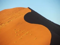
One of the spectacular quartzite cliffs. ©LB - notesfromafrica.wordpress.com

A close-up of the cliff face above. Note the "hollows" in the rock where big boulders would have detached from the rock face and gone rolling down into the valley below. ©LB - notesfromafrica.wordpress.com

Layers of rock which have been pushed into a vertical position. ©LB - notesfromafrica.wordpress.com

Green lichen grows on south-facing rock walls. ©LB - notesfromafrica.wordpress.com

These vertical slabs of rock are HUGE! ©LB - notesfromafrica.wordpress.com

©LB - notesfromafrica.wordpress.com

Towards the northerly end of the pass one comes to "the cross" on the right side of the road. We had a debate as to whether this was a natural rock formation or not. I think nature had some help! ©LB - notesfromafrica.wordpress.com

A close-up of "the cross" rock formation. ©LB - notesfromafrica.wordpress.com

Another huge rock cliff just before leaving the pass. ©WMB - notesfromafrica.wordpress.com
Photographing the rock formations proved to be tougher than one would expect, and it is difficult to do this awesome place justice. We had to deal with bright sunlight on north-facing slopes and deep shade on the south-facing areas and in the valleys.
Thank you to Willie for taking us on such an interesting photo drive – and for driving so carefully! Rosie (the dog – yes, she was also with us!) and I managed not to get car sick, despite all those hairpin bends.


They have a saying about southern Lebanon: “is there is a heaven this is what it would look like, if there is a hell, this is what it would feel like”, it kind of reminded me of that in a way. Did you use hell because of the name of the place or was there more to it? (Loved the photos by the way, they are amazing)
That is an interesting saying! Yes, you’re right it does seem like that when you’re there – beautiful creations and absolute destruction and desolation rolled into one. “The Hell” actually refers to a very narrow valley which runs down from the Swartberg Pass area. You can read more about that here: http://southerncape.wordpress.com/2011/01/12/aloes-in-die-hel-june-2002/
Thank you for visiting my blog and leaving a comment! 🙂
Wow, Lisa, these are stunning photos! What a magnificent place! Glad to know you avoided getting car sick and that Rosie got to go along for the ride. Does she like to travel in the car as much as our dogs? Ralph and Lucy LOVE it! Great post, Lisa!
Kathy
Thanks! Rosie had never been on a long drive until this past weekend. We decided to take her not knowing what to expect. She was SO good the whole trip (over 6 hours of driving). She and our friend Riekie sat on the back seat – both behaving beautifully! 😉 We let Rosie out at regular intervals to walk her, and give her water and a snack. I’m not sure if she liked the long car trip, but she definitely would rather be with us, than be left at home.
Fantastic photos from a fantastic part of the country – well done for braving the chills! It has been a long time since my mother and I travelled along this road in a little Citi Golf (!) happily tootling along, admiring all the rock formations that the Cape Fold Belt has to offer 🙂
Thanks! I can imagine that as a geologist you would find all those beautiful rocks very interesting. We actually also drove the Swartberg Pass a couple of times in my old car (also a Citi Golf!). Driving it in a Land Cruiser is definitely easier and less bumpy!
Wow, this is awesome.
I am glad the a bit of the awesomeness of the place came through in the photos. It’s really difficult photographing such huge cliffs well.
I haven’t seen this place in person but your photos are pretty incredible. I especially love the first one with the aloe ferox!
Thanks! I was looking for a nice photo of aloes the other day, so when we saw these flowering aloes, I was determined to get a good shot!
You guys took really great photos!
Thanks! Hope to see some of yours on your photoblog soon . . . 😉
AMAZING pics! Just stunning!
Thanks! The place is absolutely awesome – in-between taking photos, we just stood and gawked.
Can I just say that your new theme is looking amazing!? – The Home Page is particularly looking great. It is eye catching and, without being too cluttered and busy, shows off your posts/articles to perfection!
Thank you for the feedback! 🙂 You must be one of the first people to see it. Still have to restore some of my widgets
The scenery is spectacular – great photos.
Thanks! Yes, it is spectacular there.
Thank you for taking us on this photo tour. It’s absolutely stunning! (And your photography skills are very sharp!)
Those vertical slabs of rock look like you could just peel them away with the flick of a fingernail. I loved the arial shot of the winding road through the hills below.
Thank you for your kind comments! 🙂 I’m just glad that the awesomeness of the place translated into photos which others can appreciate.
The aerial shot of the winding road is one of my favourites too. I was remarking to Willie (we were both taking photos that day) that I took a lot of the close-ups of things, whereas he put things in context by taking zoomed out photos which helped me tell the story of our trip.
what a beautiful trip you took!!!
Yes, it was amazing. Thanks for visiting!
Ohhh… I am quite breathless and speechless, Lisa.
Wowwww.
I would think that this is the time when one really needs a WIIIIIDE-angle lens, preferably with some sort of panorama setting. Well one for capturing the grandeur of this magical place.
Breathless and speechless is a good description of what we were as well! And very cold – at least on the southern side of the mountains.
I think it requires people with a lot better skills and equipment than we have, to really do this place justice. And more time. It was an over 6-hour round-trip for us, so we weren’t stopping too long at each photo stop. Ideally one would want to stay over in Prince Albert and take a day to explore the Swartberg Pass.
Great history and photos! I love the pictures of the ruins, and I think you captured the rock formations quite nicely! If I had a Willie, I’d have him drive too…sounds like a fun trip.
Thanks for your kind comments. Yes, a Willie can be very useful to have around! 😉
Yes, it would be fabulous to have more time to explore the pass, find a good vantage point, set up the camera on a tripod, wait for the light to be *just right*… but from descriptions it is clear that even stopping at the roadside here is a challenge!
Have you heard of the Donkey Trail that goes up and over the mountains into Gamkaskloof? Have a look here: http://www.donkeytrail.com/. It’s on our ‘we definitely gotta do this’ list.
There are some places you can pull off the Swartberg Pass, so I think your idea is a very good one. But you would really have to scope out the pass to pick the right spots.
Going to tell Willie about the Donkey Trail – sounds like something he would enjoy! Thanks for the link.
Gorgeous! Amazing how giant rock can look like it folds and bends on itself. The rock pushed in a vertical position is amazing. And the one shot of the giant boulder sitting on top of other rocks…I shudder to think when it will topple down. Thank you for the link.
Thanks for coming to read this post. The layers of rock are actually folded and pushed vertically under extreme pressure. The big boulders can and do come tumbling down from time to time. So usually if there has been a lot of rain or snow, they close the pass because that is when a rockfall is most likely to happen.
Pretty rugged terrain, those Bains’ were engineering pioneer, heroes?
Yes, you can’t look at these passes and not be awestruck by the achievements of the people who built them.
Those rock formations are amazing! Great photos…looks like a worthwhile trip for the sights!
I’ve been through the Swartberg Pass several times, and never get tired of looking at those rocks.
Thanks for visiting my blog and leaving a comment! 🙂
Hi,
We are thinking of driving from Cape Town to Plett and would like to drive the pass one way and back via the coast the other. We are thinking of hiring a Toyota Corolla and not a 4×4 do you think we can drive in a normal car? Would you know how long it takes from Cape Town to Plett via the Pass?
Love your post and photographs, thanks and look forward to hearing from you 🙂
Hi Sarah!
Sorry for this delayed response . . . Yes, you can drive the Swartberg Pass in an ordinary car – we’ve done it in a VW Citi Golf! However, I wouldn’t advise it if it is raining heavily.
Thanks for visiting my blog and for your kind comments! 🙂
Hi – I know it’s an old post, but in case somebody else was thinking about this pass: I did it ~5yrs ago in a new BMW 3 series. A little bumpy, but we didn’t ground out at all and I don’t think there was any wheelspin at all, although the “gravel road sensor” did seem to know that we were off tarmac. Very enjoyable, but I’m not sure I would have attempted it in any sort of rain. Check the road status in advance though as it is sometimes closed off entirely if there have been any rockfalls / floods / fires.
Hi! Sorry for replying to this so late. The Swartberg Pass was badly damaged during heavy rains/floods during the year and is closed to all traffic.