This post is part of Kalahari Series II – 2011. The previous post in the series is Gemsbok Graphics. Also see Kalahari Series I – 2009.

Map: Upington to Twee Rivieren. (Source: Google Maps) – Click on map to enlarge
As I left you all hanging in Upington, I figured it was time to complete The Long Road North.
The second day of travelling up to the Kalahari, is always a shorter one for us. This gives us time to buy last-minute provisions and medical supplies in Upington. And to sort out any problems with the vehicle encountered during the first day.
The initial journey from Upington to the main gate of the Kgalagadi Transfrontier Park (KTP) is a three hour drive. For anyone staying over in Upington and travelling up to the KTP the next morning, I’d advise making your first camp in the KTP within a 3 hour drive of the main gate. This means either stopping at Twee Rivieren, Kielie Krankie, Urikaruus, Kalahari Tented Camp or Mata Mata. See the KTP map here (the map also shows the travelling times between the camps). The Nossob camp which is a three and half hour drive from the gate, is still doable, but it doesn’t leave much time for game viewing along the way, unless you leave Upington really early.
In this part of the journey one makes the transition between the relatively flat Northern Cape to the dune system of the southern Kalahari.

One extremely straight, flat road. Quite literally – the roads up to the Kalahari were built without a proper camber. ©LB/notesfromafrica.wordpress.com
The two most interesting features along this stretch of road, are the salt pans and the dunes.

Satellite image showing salt pans as white patches. (Source: Google Maps)
The salt pan which we stopped to take photographs at is so big I could not fit the whole thing into one shot. Even between the first two photographs below, one can see the change in the landscape.

The southern end of the salt pan. ©LB/notesfromafrica.wordpress.com

The northern end of the salt pan. ©LB/notesfromafrica.wordpress.com

Salt “mining” in progress. ©LB/notesfromafrica.wordpress.com
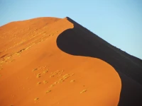
It is at this salt pan that one glimpses the first red Kalahari dunes.

Close-up of the first series of red Kalahari dunes at northern end of salt pan. ©LB/notesfromafrica.wordpress.com

An old deserted building. Wonder if this was the old “Molopo Kalahari Lodge”?! ©LB/notesfromafrica.wordpress.com
North of the salt pans the road gets more interesting as it cuts through the dune system. The little “hills” in the photographs below are dunes.

Driving through the dunes. Finally a bend in the road! ©LB/notesfromafrica.wordpress.com

The road also goes up and down through some of the bigger dunes where the road only cuts through the tops of the dunes. ©LB/notesfromafrica.wordpress.com
To see what this area looks like from above, it is interesting to look at the satellite image of the area which is available on Google Maps.

What looks in this satellite image to be ripples in sand, are in fact huge sand dunes. (Source: Google Maps) – Click on map to enlarge
Getting close to the Kgalagadi Transfrontier Park, one goes past some privately owned farms. Some of these are game farms with lodges; others are farms with domestic farm animals especially goats.

A Kalahari farm house, close to the Kgalagadi Transfrontier Park. ©LB/notesfromafrica.wordpress.com
And then you are finally there . . .

The main gate to the Kgalagadi Transfrontier Park. ©LB/notesfromafrica.wordpress.com
To the right of this gate is the main park office and reception area which I described in the An oasis in the desert post.
The Kalahari 2011 Series:
- An oasis in the desert
- Take your camera to the bathroom (and other Kalahari safari tips)
- The Long Road North – Southern Cape to Upington
- The Long Road North – Upington
- Showing your kid where its food comes from
- Fierce Creatures
- Gemsbok Graphics
- The Long Road North – Upington to Twee Rivieren and beyond (this post)
- Campfire story: The Last Outpost
- Slip-Slap-Slop-Slide and other Bush Beauty Tips
- Nossob
- Hey Mom . . . wait for me!
- A tough customer
- Frenzy at the “water hole” – includes the movie
- The Camp Cat


These posts would have to be so incredibly helpful to folks planning on making this trip–to others simply fascinating for educational and enjoyment purposes. The google satellite image of the dunes is amazing, Lisa. I’m so glad you included it.
Thanks for this great series!
Kathy
Thanks Kathy! Yes, I hope people planning Kalahari trips will find the posts helpful. I basically wrote this post just so that I could include those satellite images! 😉
The satellite image really shows the dunes in a completely different perspective 🙂 What a great idea to include it!
I was actually wondering what the Super Pit in Australia looks like on a satellite photo.
I guess I shall have to include one when I write up the full post on Kalgoorlie… It’s massive and can easily be seen from space 🙂
Looking forward to it!
Very interesting. Love the satellite.
Glad that you liked the post. It’s always difficult describing a journey like that – especially through semi-desert!
Amazing landscapes! It is a bit like Australia in some ways.
We like them too – they’re very different from the area which we live in. Yes, I agree there are lots of similarities between Australian and South African landscapes.
Those satellite images are really neat. To see the ripples in the lanscape and the white salt patches from that far into the atmosphere really gives one a different perspective.
I love looking at aerial and satellite photographs – as you say it give one a totally different perspective.
I am planning to take up this trip but I was wondering as to what possibilities are there in getting maybe a breakdown in this wilderness. What precautions can you take.
Hi Mpho! I see from your blog that you are into bird watching. You are going to love the Kalahari! We have seen such a variety of birds there – especially the raptors.
RE: Breaking down in the wilderness. Obviously, you need to make sure that your vehicle is in good working order before going. We usually have our vehicle serviced and checked out beforehand – and then basically hope for the best! 😉 Where in the Kalahari will you be going? In the Kgalagadi Transfrontier Park they have a system of logging permits. So if you leave camp, you fetch your permit from them and tell them where you are going. If you don’t arrive in your next camp, or come back to camp again, they send somebody else to look for you. So even if you just go for game drives, it’s a good idea to tell somebody which road you’re taking. People have obviously had car issues in the Park, but if it’s a serious issue, the park officials will get help for you. If you’re outside of the National Parks, it’s probably better not to travel on your own. In that case at least two vehicles would be best (but not always possible . . .).
I’ll be looking out for your photographs of your trip! Thanks for visiting my blog and leaving a comment. 🙂